 Tweet
Tweet
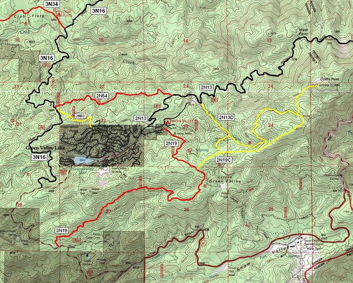
Well, thanks to FishPOET's (Doug's) map, Mr. Green finally made it to the top of Craft's Peak. The peak is near Green Valley, California. The map that helped us to find the way looks like this:
The trouble finding the trail on the last attempt is due to the trail being marked as 2N19A, but on my OHV Guide map from the USFS, this trail is marked as 2N13D. Doug's map shows the same. This is especially confusing, since the trail spurs off of 2N13 and not 2N19. The trail that I thought was the way on last week's run is not a designated trail. So the dirt pile in front of it was needed (But I'm still sad that the bulldozer driver had to knock down a living tree to do so).
Regardless, I'm glad that we didn't go to Craft's Peak by the trailhead from 2N13 because going from 2N19 is a far more interesting drive! Scherf68 (Jim) PM'ed us to see if we were going anywhere on Monday, and (of course) we were, so we invited him along. I'm glad that we did because not only do I truly enjoy his company, the trail turned out to be more remote and difficult that I expected.
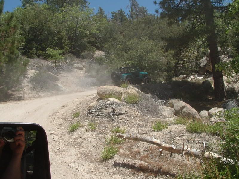
The trail from Green Valley Lake road is easy but dusty:
It is very scenic but not a very challenging drive. Jim found ways to entertain himself though:

2N19 does not have any designated spurs until 2N19B, but there is one logging trail that leads down to a pine-filled grotto beside a meadow that is probably very wet most of the season. Unfortunately, it was very dry at this time. We picked up some trash left by eariler visitors and then headed on down 2N19.
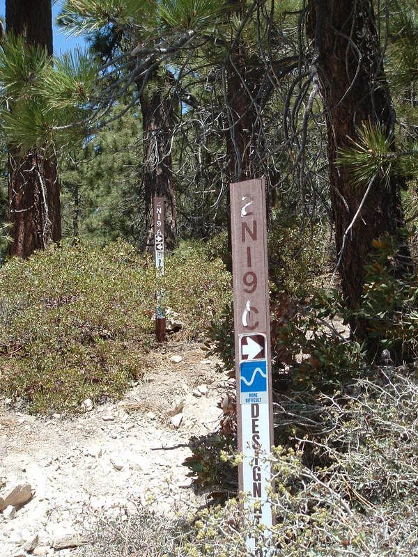
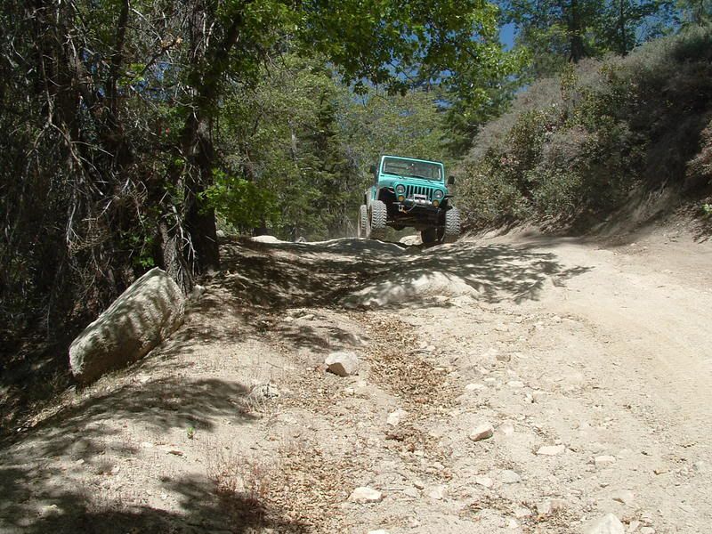
Soon we reached the turn off for 2N19B. On my map, this is a dead-end spur. This is not the case at all. The trail heads East for a while until you find the spur for 2N19C. This is the fun stuff! Not far into 2N19C, we decided that we might want to air down now. The climbs are steep and rocky. The views are wonderful:

The best climb was steep enough to cause Mr. Green to almost stall in 4WD High. We had to stop and shift to 4WD Low to finish the climb. Hills are always tough to give justice to in a photo. This hill is much longer than you can see and much steeper that the camera can give visual effect of:

Eventually, we get to the trail to Craft's Peak. This is when I learn that the trail is not designated as my map shows:
The turn onto the trail is off-camber and is one of the spookier parts of the trail. Again, the camera just doesn't capture the steepness of the hill:
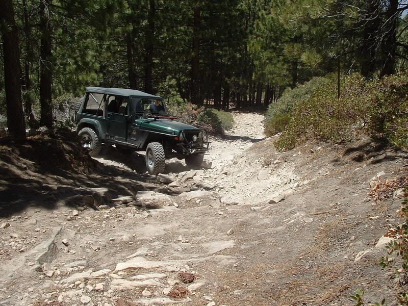
The first ledge of the trail is not as hard as it first appears, but it can bring you to a stop if you pick the hardest line:


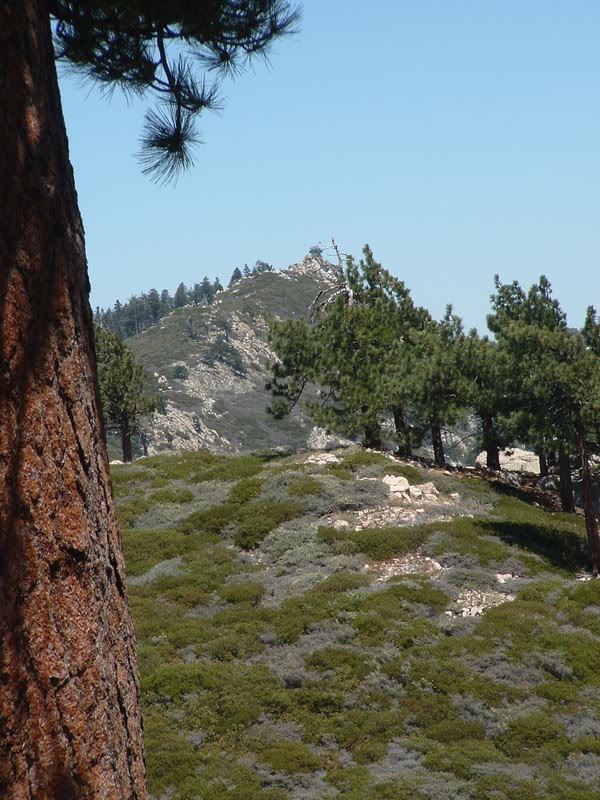
After a loose rock climb similar to White Mtn (3N17), you finally get to the top of Craft's Peak:

The views are fantastic! The closest peak is Butler and you can see the Fire Watch Station (by the way, I hear that it is manned now. Fire is a SERIOUS concern - please do your part to prevent them!):
After exploring and rock climbing on foot, we headed back down Craft's Peak (2N19A):

Along the way, we passed a rubber chicken attached to a tree. I don't know why its there, but I knew that no one would believe me without a photo:

We followed 2N19A to the point where 2N19B joined again. We took 2N19B back to 2N19 and headed toward Green Valley. Along the way, we met up with Bob, Jim and others from the Victor Valley 4-Wheelers. They had been to Butler Peak and were planning to run DishPan downhill. I was tempted to join them since Scherf68 hadn't been on it before, but I had to pass since it was late in the day.
There was still enough time to run a couple of more trails. We crossed pavement in Green Valley briefly before getting onto 2N13 for a short run. We turned onto 2N54 towards Crab Flats. It is a moderate trail with excellent views:
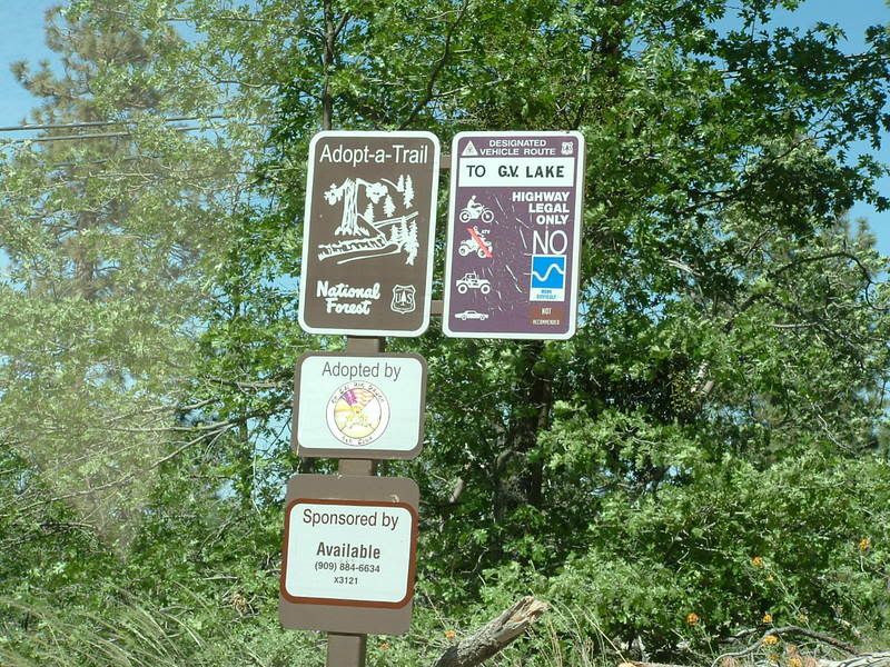
At Crab Flats staging area, we turned onto the short but fun trail of Edison Road (2N83). The trail sign amuses me with the Not Recommended portion for street vehicles:
You be the judge, would you take your mini-van up this?:


I am still uncertain that the USFS got the Blue Square right for this trail. Mr. Green rubbed on a lot of skid plates going up this one.
The cool thing is that the trail drops you out into the residential area of Green Valley. We reconnected because it is all paved roads out from there:

The Green Valley area is a hidden jewel in the forest. The area hasn't burned (yet!), so the forest is wonderful to view and explore. The trails are challenging but not hard. I highly recommend that if you haven't been here before, that you should make time to visit.
Thank you to FishPoet for info about the trail and thank you to Scherf68 for joining us on the adventure!
All the pics can be viewed here:
http://s139.photobucket.com/albums/q...28-07/?start=0
The trouble finding the trail on the last attempt is due to the trail being marked as 2N19A, but on my OHV Guide map from the USFS, this trail is marked as 2N13D. Doug's map shows the same. This is especially confusing, since the trail spurs off of 2N13 and not 2N19. The trail that I thought was the way on last week's run is not a designated trail. So the dirt pile in front of it was needed (But I'm still sad that the bulldozer driver had to knock down a living tree to do so).
Regardless, I'm glad that we didn't go to Craft's Peak by the trailhead from 2N13 because going from 2N19 is a far more interesting drive! Scherf68 (Jim) PM'ed us to see if we were going anywhere on Monday, and (of course) we were, so we invited him along. I'm glad that we did because not only do I truly enjoy his company, the trail turned out to be more remote and difficult that I expected.
The trail from Green Valley Lake road is easy but dusty:
It is very scenic but not a very challenging drive. Jim found ways to entertain himself though:
2N19 does not have any designated spurs until 2N19B, but there is one logging trail that leads down to a pine-filled grotto beside a meadow that is probably very wet most of the season. Unfortunately, it was very dry at this time. We picked up some trash left by eariler visitors and then headed on down 2N19.
Soon we reached the turn off for 2N19B. On my map, this is a dead-end spur. This is not the case at all. The trail heads East for a while until you find the spur for 2N19C. This is the fun stuff! Not far into 2N19C, we decided that we might want to air down now. The climbs are steep and rocky. The views are wonderful:
The best climb was steep enough to cause Mr. Green to almost stall in 4WD High. We had to stop and shift to 4WD Low to finish the climb. Hills are always tough to give justice to in a photo. This hill is much longer than you can see and much steeper that the camera can give visual effect of:
Eventually, we get to the trail to Craft's Peak. This is when I learn that the trail is not designated as my map shows:
The turn onto the trail is off-camber and is one of the spookier parts of the trail. Again, the camera just doesn't capture the steepness of the hill:
The first ledge of the trail is not as hard as it first appears, but it can bring you to a stop if you pick the hardest line:
After a loose rock climb similar to White Mtn (3N17), you finally get to the top of Craft's Peak:
The views are fantastic! The closest peak is Butler and you can see the Fire Watch Station (by the way, I hear that it is manned now. Fire is a SERIOUS concern - please do your part to prevent them!):
After exploring and rock climbing on foot, we headed back down Craft's Peak (2N19A):
Along the way, we passed a rubber chicken attached to a tree. I don't know why its there, but I knew that no one would believe me without a photo:
We followed 2N19A to the point where 2N19B joined again. We took 2N19B back to 2N19 and headed toward Green Valley. Along the way, we met up with Bob, Jim and others from the Victor Valley 4-Wheelers. They had been to Butler Peak and were planning to run DishPan downhill. I was tempted to join them since Scherf68 hadn't been on it before, but I had to pass since it was late in the day.
There was still enough time to run a couple of more trails. We crossed pavement in Green Valley briefly before getting onto 2N13 for a short run. We turned onto 2N54 towards Crab Flats. It is a moderate trail with excellent views:
At Crab Flats staging area, we turned onto the short but fun trail of Edison Road (2N83). The trail sign amuses me with the Not Recommended portion for street vehicles:
You be the judge, would you take your mini-van up this?:
I am still uncertain that the USFS got the Blue Square right for this trail. Mr. Green rubbed on a lot of skid plates going up this one.
The cool thing is that the trail drops you out into the residential area of Green Valley. We reconnected because it is all paved roads out from there:
The Green Valley area is a hidden jewel in the forest. The area hasn't burned (yet!), so the forest is wonderful to view and explore. The trails are challenging but not hard. I highly recommend that if you haven't been here before, that you should make time to visit.
Thank you to FishPoet for info about the trail and thank you to Scherf68 for joining us on the adventure!
All the pics can be viewed here:
http://s139.photobucket.com/albums/q...28-07/?start=0
Comment