Announcement

Collapse
No announcement yet.

Panamint & Death Valley

Collapse

Forum Thread First Post

Collapse
X
 
  • Filter
  • Time
  • Show
Clear All
new posts

  • Panamint & Death Valley

    I have always wanted to camp for a weekend in the Death Valley area. See the Race Track. Explore the desert mountains... Ya know, the kinda stuff that I grew up watching on "The Wonderful World of Disney" in Georgia and thinking that I would never get the chance to do. Well, I finally conned...er..talked some friends into going!

    Jake and Mandy (Cherokee People) seem to not mind my half-baked plans. They even went up a day early to see some of the places that Sharon and I have already been. We came up on Friday to meet them in the evening.

    DAY ONE

    Big Four Mine
    It is already warm on the valley floors (mid 90's) so we started up the Big Four Mine trail early on Saturday. The Trail past the Lake hill is easy running except for a few ruts and some wash-board spots. Once the trail turned and headed up into the canyon, the trail became very faint:


    We scouted the trail and after deciding that it was getting hot really fast, we turned back and headed for higher ground.

    Pleasant Canyon / South Park Trail
    Higher ground meant a very popular trail: Pleasant Canyon/South Park Trail.
    Pleasant Canyon is the canyon on the left and South Park Trail is the scar that comes down the face of the mountain to the right:


    This trail is so popular that two large groups from 4x4HIM.org were staging to go up the trail. The first group was going up South Park and the second group was going up Pleasant. We were leaving as the first group left, so we chose to climb the Pleasant Canyon side to avoid the crowd.

    If you have never run this trail, you really should! The Pleasant Canyon trail is a creek bed in many places:

    With mine camps and cool canyon scenery along the way and especially at the top:


    We went to Rogers Pass and then down into Middle park. We took a wrong turn and ended up at a canyon without a drivable trail, but the view was awesome:


    After returning to the main trail, we entered South Park, where we saw Kenny!:


    Unforunately, he was killed by the feral Burros:


    Leaving South Park, the down hill run starts with a cave of trees at Colter Spring:


    The trail leads down at this point and winds along a shelf road. There is one scary spot from the driver's seat, but the pics didn't do it justice. There is a cool bridge built by the miners:


    And a sparce amount of mildly technical stuff:


    But all-in-all, my Moderate rating is fairly generous if you consider the whole trail.

    After getting down off the mountain, it was still hot on the valley floor, so we headed up hill to the Charcoal Kilns:


    These were used during the early mining days to make charcoal to help in the mining process.
    [COLOR=#ff8c00]MYJEEP(crawls)ROCKS(again).com

    I have finally stopped drinking for good.
    Now I drink for evil..... :devil:
    [/COLOR]

  • #2
    Day Two

    As day two started, we headed out very early to see the Racetrack Playa. The Moving Rocks have always been on my "try to do before I Die" list. But driving 27 miles of wash-board roads to get there didn't seem like fun. When I found out that there was a back way in that might require some serious four-wheelin'...well, you know the rest.

    We wanted to get to the Racetrack quickly, so not many pics were taken on the way. The trip up Saline Valley Road to the Grapevine Canyon was quick (despite the tractor trailers full of cattle along the way, WEIRD!) Most of the pics were on the way back.

    When we got the Lippincott Grade, things got interesting:


    But the goal was the Racetrack Playa and seeing the moving rocks:


    After the Playa, Jake and Mandy needed to get home, so they took the short way out. Sharon and I returned down the Lippincott Grade (where you spend a lot more time tilting towards the Abyss than a guy who has rolled his Jeep cares for!):


    Going back up Grapevine Canyon, you might be surprised at the number of water crossings:


    Exiting back down Saline Valley Road, there is an absolute FOREST of huge Joshua Trees:


    Back on pavement, we decided to try to find the Snow Canyon Trial and find the Golden Lady Mine. We followed the directions to the start of the trail according to the the book I have by Roger Mitchell. But somewhere along the way, we followed the wrong tire tracks. I wasn't worried until we found what was left of a wild burro:


    You gotta think... if a Burro took out Kenny, what could have taken out the Burro?

    We followed a rough but tire marked trail towards a canyon entrance. We found the remnants of old buildings:


    With a little manuevering, we found a well traveled road that led to a mine. Later we learned that we were at the Minnietta Mine:


    Very cool! And a much easier way back out. But I still wanna see the Golden Lady Mine. I guess that it will have to wait until next time. It was a great trip, but there is still SOOO much more to see! I'll send a link to the rest of the photos soon. The Cherokee People may have some photos later too.
    [COLOR=#ff8c00]MYJEEP(crawls)ROCKS(again).com

    I have finally stopped drinking for good.
    Now I drink for evil..... :devil:
    [/COLOR]

    Comment


    • #3
      wow! thats nice! i'm going to be in Death Valley the weekend of April 13. this is going to help alot with trail decisions. going to have a chevy tahoe, quad cab tacoma, tacoma, and my wj going. should be a fun weekend

      Comment


      • #4
        if you don't mind, may i ask what is the back way to the race track? i would love to wheel that trail if possible and see the race track.

        Comment


        • #5
          Originally posted by phant0omx View Post
          if you don't mind, may i ask what is the back way to the race track? i would love to wheel that trail if possible and see the race track.
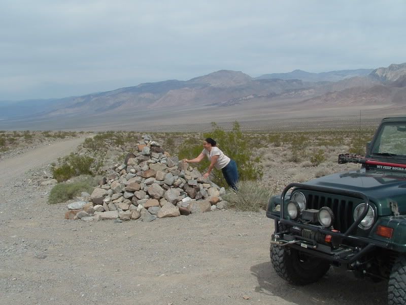
          The back way is to take the 190 West from Panamint Springs 13 miles to Saline Valley Road (just outside of the Death Valley Park). It is clearly marked from 190. It is a broken pavement road for a long way (about 8 miles). Go right into the Josha Tree forest right after the "pavement" ends. At about 15 or 16 miles from 190, you will reach a "Y" intersection (just past some excellent views of the Panamint Dunes and Valley). Turn Left into Grapevine Canyon. After you get out of Grapevine Canyon and head downhill toward the Saline Valley floor (with some excellent views BTW), the first Right will be Lippincott Grade road. It is the first intersection after the Grapevine but to make it obvious, there is a stone ciarn about 5 feet high at the corner (we, of course, added stones on our way back):


          Follow the trail up hill to the Racetrack Trail. I really wish that I could go with you! We had a great time. I'm sure that you will too! Be careful with the Tahoe, the wide track may have trouble on the narrow self road.

          PS: You should REALLY make time to do Pleasant Canyon and South Park.
          Last edited by Mike; 03-27-07, 08:03 AM. Reason: corrected directions
          [COLOR=#ff8c00]MYJEEP(crawls)ROCKS(again).com

          I have finally stopped drinking for good.
          Now I drink for evil..... :devil:
          [/COLOR]

          Comment


          • #6
            More Pics!

            If you are interested, the majority of my pics are at this link:
            http://s139.photobucket.com/albums/q...%2007/?start=0
            [COLOR=#ff8c00]MYJEEP(crawls)ROCKS(again).com

            I have finally stopped drinking for good.
            Now I drink for evil..... :devil:
            [/COLOR]

            Comment


            • #7
              Mike,

              Great pictures and great report! I felt like I was there with you.

              Russ
              If you don't like the way I drive, stay out of the bushes!
              KI6MLU

              Comment


              • #8
                Cool! thanks for posting that. I am leading a Land Rover group up there near the end of April (got 100 Rovers signed up! - not all the same trail of course :-), and I am unfamiliar with the area.

                I have also always wanted to go to Devils Race track, so I'm really looking forward to it. Your photos make it that much more desirable to get up there!
                Off road adventure photography:

                TreadLightly Trainer
                Wilderness First Aid (WFA)
                HAM - KI6PFO

                2005 Rubicon Unlimited + trailer

                Comment


                • #9
                  Nice pictures. I was there also in the 4x4him group you passed on the way to pleasant valley.
                  <><
                  4x4him.org

                  Comment


                  • #10
                    wow....neat!!! whimper whimper...I wanna go.
                    "If you have significant difficulty here, dont go any further....it only gets worse".
                    (Charles Wells)

                    Comment


                    • #11
                      Great pics and report. Our spring trip to DV had to be postponed and now I am very much looking forward to our November trip.
                      Over 2500 hours donated to the San Bernardino National Forest. Life member of CA4WD, CORVA & BRC. Tread Lightly Trainer. Reforestation Supervisor. CASSP

                      Comment


                      • #12
                        Originally posted by Malachi View Post
                        The back way is to take the 190 East from Panamint Springs 13 miles to Saline Valley Road (just outside of the Death Valley Park). It is clearly marked from 190. It is a broken pavement road for a long way (about 8 miles). Go right into the Josha Tree forest right after the "pavement" ends. At about 15 or 16 miles from 190, you will reach a "Y" intersection (just past some excellent views of the Panamint Dunes and Valley). Turn Left into Grapevine Canyon. After you get out of Grapevine Canyon and head downhill toward the Saline Valley floor (with some excellent views BTW), the first Right will be Lippincott Grade road. It is the first intersection after the Grapevine but to make it obvious, there is a stone ciarn about 5 feet high at the corner (we, of course, added stones on our way back):


                        Follow the trail up hill to the Racetrack Trail. I really wish that I could go with you! We had a great time. I'm sure that you will too! Be careful with the Tahoe, the wide track may have trouble on the narrow self road.

                        PS: You should REALLY make time to do Pleasant Canyon and South Park.
                        OOPS! I said 13 miles East of Panamint Springs, that should have been WEST! I'll edit the original post.
                        [COLOR=#ff8c00]MYJEEP(crawls)ROCKS(again).com

                        I have finally stopped drinking for good.
                        Now I drink for evil..... :devil:
                        [/COLOR]

                        Comment


                        • #13
                          Wow, what a great experience! We still haven't been there. Great pics and report.
                          :gun:'99 TJ Sport:gun:

                          Comment


                          • #14
                            Wow great report and pics thanks for sharing and now i must add this to my to due list.
                            01 Tj Sport 4.0 Auto
                            4 RE, 1" Bl-MM, 33" with 6" flares and ORF tire carrier
                            SYE kit with ARB F/B 4.56

                            Comment


                            • #15
                              Originally posted by Malachi View Post
                              If you are interested, the majority of my pics are at this link:
                              http://s139.photobucket.com/albums/q...%2007/?start=0

                              If you go again, I would like to come along. Death Valley is one of those places I can't get enough of. Great photos and report, thanks.

                              Kurt
                              [CENTER][COLOR=#ff0000]Resistance Off Road
                              [/COLOR]Join the Resistance...
                              http://www.resistanceoffroad.us[/CENTER]

                              Comment

                              Working...
                              X