Announcement

Collapse
No announcement yet.

Grand Canyon Parashant National Monument

Collapse

Forum Thread First Post

Collapse
X
 
  • Filter
  • Time
  • Show
Clear All
new posts

  • Trail Report: Grand Canyon Parashant National Monument

    The "Arizona Strip" refers to the area in northwestern Arizona between the Colorado River and the Utah border. It includes the Lake Mead National Recreation Area, the north rim of the Grand Canyon National Park, and the Grand Canyon Parashant National Monument. I just returned from a week in the Arizona Strip with a group from San Diego. We had planned on an orderly jaunt from Mesquite, NV to Toroweap Point and return, but a fuel pump failure in the middle of the Parashant, 65 miles from the nearest pavement, forced a detour to Cedar City, UT to get a replacement part and led us to criss-cross the Parashant:


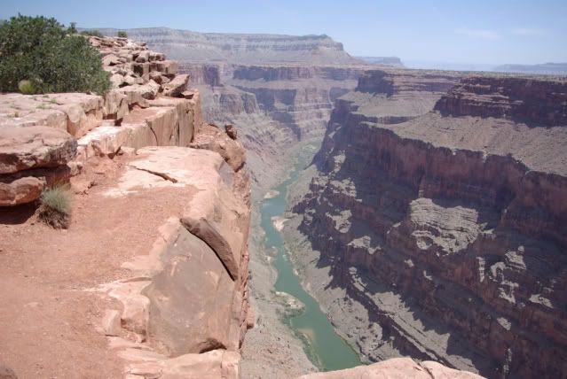
    One of the highlights of the trip was our visit to Toroweap Overlook, 3000' above the Colorado River:


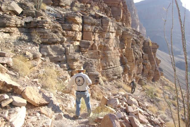
    Another highlight was camping at Whitmore Canyon, just a tenth of a mile from, but 800' above the Colorado River:


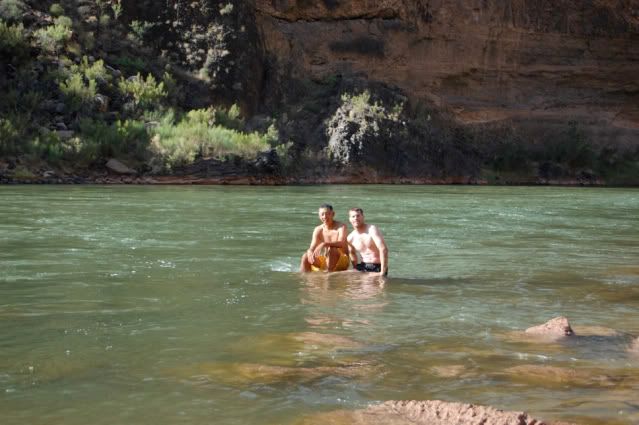
    And a refreshing dip in the chilly Colorado River after a hike down from our campsite:


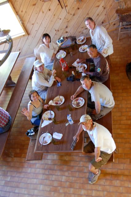
    No visit to the Arizona Strip is complete without a stop at the Bar 10 Ranch near Whitmore Canyon. Here's our group helping me celebrate my birthday with a dinner in the lodge:


    Here's a link to more pictures:

    http://s17.photobucket.com/albums/b5...view=slideshow
    If you don't like the way I drive, stay out of the bushes!
    KI6MLU

  • #2
    Really pretty view,s there Russ as always we get walked thru your trips!!Thanks my bro miss all your pic,s and reports...Geeb
    "A man who fears suffering,is already suffering from what he fears"!

    Comment


    • #3
      Happy Late Birthday! Thanks for sharing those great pictures, looks like a great time!
      If we aren't supposed to eat animals, then why are they made out of meat?

      http://jeep.matandtiff.com/

      Truth is treason in the empire of lies. -Ron Paul

      Comment


      • #4
        Great pictures Russ. Thanks for sharing.
        Check out .

        Comment


        • #5
          What an amazing country that we can drive our Jeeps around to places like this. Just added this to one to my “trips before I die” list. Next April I am going to Hollister Hills because I was inspired by one of Russ's trip reports.
          Those left standing
          Will make millions
          Writing books on ways
          It should have been
          -Incubus "Warning"

          Comment


          • #6
            Russ,

            That looks like a spectacular place to go!

            Thanks for sharing that.

            Happy belated Birthday!

            Christian
            "People demand freedom of speech to make up for the freedom of thought which they avoid." - Soren Aabye Kierkegaard (1813-1855)

            Comment


            • #7
              Great Pics Russ! Looks like a fantastic trip.
              [COLOR=#ff8c00]MYJEEP(crawls)ROCKS(again).com

              I have finally stopped drinking for good.
              Now I drink for evil..... :devil:
              [/COLOR]

              Comment


              • #8
                Great pictures!

                Comment


                • #9
                  Russ! Happy Birthday! How did you get down to the river?
                  :gun:'99 TJ Sport:gun:

                  Comment


                  • #10
                    Originally posted by sarah View Post
                    Russ! Happy Birthday! How did you get down to the river?
                    There's a hiking trail from the Whitmore Canyon overlook to the river. The trail is about a mile long, with an 800 foot elevation change (about 2400' elevation at the overlook and about 1600' elevation at the river). It took about 45 minutes to hike down and about an hour and fifteen minutes to hike back up. Once the sunlight reaches the bottom of the canyon, there is NO SHADE on the trail. We hiked down at about 7am and hiked back up at about 10am, and it was already getting hot. I suggest going in the late afternoon when there is more shade in the canyon and bring plenty of water or Gatorade. I brought my Garmin GPS V with me so I could be encouraged (discouraged?) to know how many more feet we had to descend/ascend.

                    If you don't like the way I drive, stay out of the bushes!
                    KI6MLU

                    Comment


                    • #11
                      Looks like a great place.
                      Thanks, I'll have to add that to my list as well

                      Scott

                      Comment


                      • #12
                        Originally posted by Russ Chung View Post
                        There's a hiking trail from the Whitmore Canyon overlook to the river. The trail is about a mile long, with an 800 foot elevation change (about 2400' elevation at the overlook and about 1600' elevation at the river). It took about 45 minutes to hike down and about an hour and fifteen minutes to hike back up. Once the sunlight reaches the bottom of the canyon, there is NO SHADE on the trail. We hiked down at about 7am and hiked back up at about 10am, and it was already getting hot. I suggest going in the late afternoon when there is more shade in the canyon and bring plenty of water or Gatorade. I brought my Garmin GPS V with me so I could be encouraged (discouraged?) to know how many more feet we had to descend/ascend.
                        Thanks Russ, that's awesome. I didn't know that you could hike down and back up the same day. For some reason I thought it was much farther, or that you had to take a guided tour down. I would like to do that sometime - that looks like a really great experience.
                        :gun:'99 TJ Sport:gun:

                        Comment

                        Working...
                        X