 Tweet
Tweet
Take the time to take the survey.
http://www.planocotillowells.org/
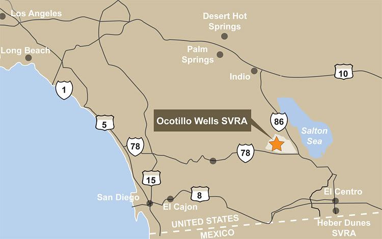
A Portion of the Freeman Property Added to Ocotillo Wells SVRA
The Freeman property (also known as Truckhaven/Desert Cahuilla) was acquired by California State Parks in 2006. Senator Denise Ducheny and Senator Dennis Hollingsworth recently convened a group of stakeholders to establish a plan for dividing the Freeman Property between Anza Borrego Desert State Park and Ocotillo Wells State Vehicular Recreation Area (SVRA).
Following the stakeholder group meetings, the plan was finalized under Senate Bill 855. This legislation specifies that the northwestern portion of the property be annexed to Anza Borrego Desert State Park and the southeastern portion of the property be annexed to Ocotillo Wells SVRA. The Ocotillo Wells SVRA addition, now called �Ocotillo Wells North� for general planning purposes only, will be included in the General Plan and EIR project that is underway.
Complete our short online questionnaire by March 31.
Help us identify key planning issues for OW North by completing the online questionnaire. Your input will help guide early project research!
Additional outreach activities in early 2011 will provide opportunities for the public and stakeholders to help identify planning issues and opportunities for Ocotillo Wells North as part of the General Plan process. Sign up to be notified of upcoming public participation activities.
http://www.planocotillowells.org/
A Portion of the Freeman Property Added to Ocotillo Wells SVRA
The Freeman property (also known as Truckhaven/Desert Cahuilla) was acquired by California State Parks in 2006. Senator Denise Ducheny and Senator Dennis Hollingsworth recently convened a group of stakeholders to establish a plan for dividing the Freeman Property between Anza Borrego Desert State Park and Ocotillo Wells State Vehicular Recreation Area (SVRA).
Following the stakeholder group meetings, the plan was finalized under Senate Bill 855. This legislation specifies that the northwestern portion of the property be annexed to Anza Borrego Desert State Park and the southeastern portion of the property be annexed to Ocotillo Wells SVRA. The Ocotillo Wells SVRA addition, now called �Ocotillo Wells North� for general planning purposes only, will be included in the General Plan and EIR project that is underway.
Complete our short online questionnaire by March 31.
Help us identify key planning issues for OW North by completing the online questionnaire. Your input will help guide early project research!
Additional outreach activities in early 2011 will provide opportunities for the public and stakeholders to help identify planning issues and opportunities for Ocotillo Wells North as part of the General Plan process. Sign up to be notified of upcoming public participation activities.
Comment