Announcement

Collapse
No announcement yet.

Marine Corps Submits Withdrawal Application

Collapse

Forum Thread First Post

Collapse
X
 
  • Filter
  • Time
  • Show
Clear All
new posts

  • Marine Corps Submits Withdrawal Application

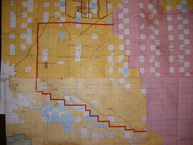
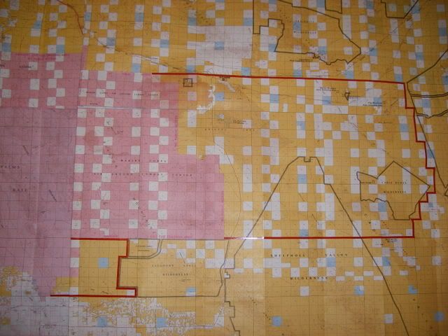
    From the Marine Corps Website. This has not been posted on the Federal Register yet, but the news is official. The Federal Register listing will include the specifics of the area withdrawn and a map will be available soon.

    http://www.marines.mil/news/Pages/pressreleases.aspx

    Harry Baker
    Chairman
    Partnership For Johnson Valley


    Marine Corps submits withdrawal application to Bureau of Land Management


    8/19/2008
    Division of Public Affairs HQMC Media Branch


    3000 Marine Corps Pentagon, RM 4B548
    Washington, DC 20350-3000


    703-614-4309
    WASHINGTON The Marine Corps submitted a land withdrawal application to the Bureau of Land Management (BLM) for approximately 422,000 acres contiguous to Marine Corps Air Ground Combat Center, Twentynine Palms, Calif.

    The application is part of an ongoing study by the Marine Corps for possible base expansion, along with the establishment of corresponding special-use airspace, necessary to train a Marine Expeditionary Brigade at the Combat Center.

    The Marine Corps will be preparing an Environmental Impact Statement that will analyze the reasonable alternatives for meeting the MEB-training requirement. The Department of the Navy intends to publish a Notice of Intent to undertake the EIS in early November and conduct public scoping meetings in early December.

    During the EIS analysis period, the Marine Corps will continue to work with recreational and business stakeholders to include energy companies, the airline industry and off-road vehicle enthusiasts. The recreational use of this land remains the same as prior to the withdrawal application.

    Together with the BLM and the Federal Aviation Administration, we will study the best path forward for the Marine Corps to meet its training requirements, while analyzing and weighing the impact of the various alternatives on natural and socio-economic resources.

  • #2
    so does this mean I will be able to do the Hammers one day??
    Ford Raptor 6.2l

    Comment


    • #3
      Now, by withdrawal do they mean that the land with be withdrawn from the BLM and transfered to MARCOR? I'm sure the FOJV will have more answers on this as they become available.

      I drew two things from the article. One is I need someone to explain the "withdrawal" and the second is that there are meetings in December and FOJV will probalby be letting us know if they want maximum attendence or if we should let a few designated people show up. Sometimes, too many voices/opinions is counter productive and nothing gets accomplished.
      [COLOR="darkred"]"Death Smiles at Everyone... Marines Smile Back."
      Adopt-a-Trail Member.[/COLOR]

      Comment


      • #4
        I believe they are requesting that the land be withdrawn from the BLM and given to the Marine Corps

        This is certainly not good news. I was hoping it didnt get this far. The battle continues with more vengence.

        Tam
        2002 TJ on 35s a bit of lift with some stuff
        Rock-ItMan all the way around

        Comment


        • #5
          Here's something else I just got:

          MARINE CORPS AIR GROUND COMBAT CENTER AT TWENTYNINE PALMS TO STUDY 422,000
          ACRES OF LAND SURROUNDING THE BASE-INCLUDING MUCH OF A POPULAR OHV AREA-FOR
          POSSIBLE ACQUISITION


          BAKERSFIELD, CA (August 20, 2008) Marine Corps Air Ground Combat Center
          (MCAGCC) located in Twentynine Palms, CA has submitted a withdrawal
          application to the Bureau of Land Management (BLM) to essentially put a hold
          on 422,000 acres while it studies those areas for possible acquisition into
          the base.


          A large portion of the Johnson Valley OHV area is being considered. Johnson
          Valley OHV area is approximately 189,000 acres and is located in the high
          desert of California, just east of Los Angeles. The area is a Mecca for
          off-road recreation and is home to many events including off-road racing and
          competitive rock crawling.


          For the past six months the OHV community has been aware that the Marines
          are studying this area for possible expansion. As a result, a small working
          group of OHV leaders has been working with the Marines to help them
          understand just how important this area is to the Southern California OHV
          community. It is the largest open OHV area in the country, and home to a
          myriad of competition events such as motorcycle races, 2- and 4-wheel drive
          off-road races and extreme rock crawling events. Jerry Grabow, President of
          the American Motorcyclist Association District 37, Off-Road, stated "Over
          half of our race program occurs on land within the Johnson Valley OHV Area.
          We have been racing in this area for over 50 years; there is simply not
          another open area large enough to hold these types of races."


          The withdrawal application the Marines submitted requires that the BLM
          prepare a "Notice of Proposed Withdrawal and Opportunity for Public
          Meeting." When this notice is published in the Federal Register it starts a
          90-day public comment period and segregates the public land identified in
          the application for two years. Uses that are currently allowed in the area
          will continue, but no new uses or projects will be permitted. "We are
          hopeful that another solution or compromise can be found that fulfills the
          training needs of the Marines while still allowing OHV recreation to
          continue in this area treasured by so many off-road enthusiasts," stated Meg
          Grossglass, ORBA Land Use staff member.


          # # #


          ORBA is a national trade association composed of off-road related businesses
          united to promote common goals that support the prosperity and growth of the
          off-road industry.


          Meg Grossglass

          Media Relations & Land Use


          ORBA - the Off-Road Business Association

          Phone 951.926.1953

          Cell 951.415.1869

          Corporate Office

          1701 Westwind Dr. #216

          Bakersfield, CA 93301

          Corporate Office 661.323.1464

          Comment


          • #6
            According to a Marine Corps spokesperson, the study area includes lands to the east, south and west of the base. The area to the west of the base starts at the southwestern corner of the base and stairsteps to the west, across and south of the Johnson Valley Open Area, including some private lands outside of the Open Area.

            The spokesperson stressed that this is only a study area, and that the final decision will likely encompass less area than is studied.


            Helen
            PFJV

            Comment


            • #7
              The text of the study application is up on the Marine website. There are legal descriptions, I don't see a map though.

              Left side menu.

              http://www.29palms.usmc.mil/las/

              Don


              Look on pages 9-11 of the document and it lists the township, range and section number requested. You can plot the study area out on the following Desert Access Guides:

              Big Bear Lake DAG # 14 (southern Johnson Valley), Newberry Springs DAG # 11 (northern Johnson Valley), Amboy DAG # 12 (northeastern expansion area) and Sheephole Mountain DAG # 15 (east, southeast and south expansion areas)


              Helen
              PFJV

              Comment


              • #8
                In a nutshell, before the Marines can start their EIS process, they must "withdraw" the land they are interested in from "entry". This is the process by which they say "we are interested in this land, so until we say otherwise, no one else can ask for it".

                This stops any proposals for energy development, mining, or other long term uses on the land they are withdrawing while they are deciding whether or not they want it.

                In this case, do not confuse "entry" from "access". We will still have access, until they say otherwise.

                k.
                This was posted on NAXJA and is a simple explanation of the term "withdrawal."

                Comment


                • #9
                  Who or what do you have to be to file for a withdrawal? can MJR or victor valley file for it for someplace? do you have to be a government agency? because I am thinkin' we need to form an organization and do that to all these areas so they dont become windfarms or solar plants or bombing ranges...
                  :gun: my rifle is not illegal, it's just undocumented... :gun:

                  Comment


                  • #10
                    Originally posted by Kodiak Spirit View Post
                    Who or what do you have to be to file for a withdrawal? can MJR or victor valley file for it for someplace? do you have to be a government agency? because I am thinkin' we need to form an organization and do that to all these areas so they dont become windfarms or solar plants or bombing ranges...
                    We got a lot fo people fighting but were nobody whan it comes to it, heres a group that is on it like flys on poop http://www.fojv.org/index.htm everyone sign up and say hi..............................
                    Its no fun without family

                    Comment


                    • #11
                      OK, I mapped out the boundary from the legal description on the BLM maps. I'll work on getting a hi-res scan at work next week. In the mean time I spread them out on my dining table and took some pictures.

                      West expansion includes almost all of the Johnson Valley OHV area, except the west end including Cougar Buttes.

                      Here's a link to the full res version. It won't fit on your screen but you can scroll around and read the labels

                      http://i52.photobucket.com/albums/g2...OJVMapWest.jpg


                      Here is the east and south areas. The east area seems to be pretty close to the same acreage as the west. The legal description does say that the existing wilderness areas are excluded (they are outlined in gray)

                      http://i52.photobucket.com/albums/g2...OVJMapEast.jpg

                      Friends of Johnson Valley
                      Secretary.

                      Comment


                      • #12
                        Here's the 'official' map. The area to the east goes around both of the wilderness areas. On the west the map is changed to eliminate about 4 sections of tortoise area managed across Camp Rock Rock.

                        http://www.29palms.usmc.mil/las/docs...a_20080821.pdf


                        Helen
                        PFJV

                        Comment


                        • #13
                          :poop::angry:
                          Originally posted by bakerhab View Post
                          Here's the 'official' map. The area to the east goes around both of the wilderness areas. On the west the map is changed to eliminate about 4 sections of tortoise area managed across Camp Rock Rock.

                          http://www.29palms.usmc.mil/las/docs...a_20080821.pdf


                          Helen
                          PFJV
                          Just an interesting observation, the land on the east excluded as wilderness, about equals the land on the west taken away from JV :poop::angry:

                          Comment

                          Working...
                          X