 Tweet
Tweet
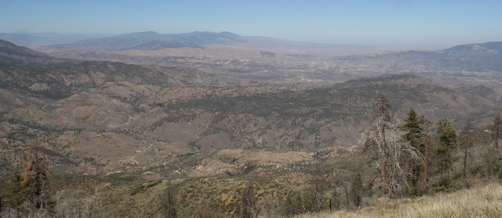
8N01 Gold Hill Road
Length: 23 miles
Elevation: 3775' to 6800'
Los Padres National Forest Los Pinos District MVUM
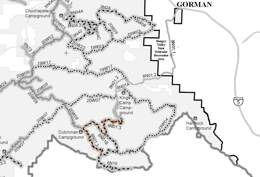
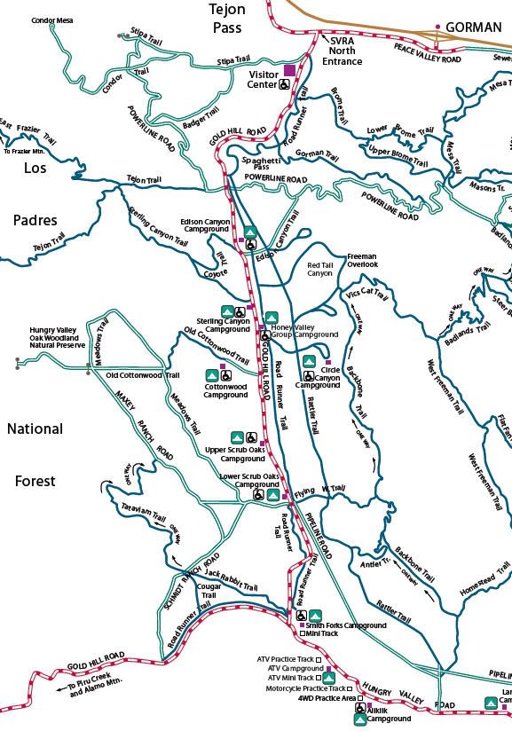
Hungry Valley State Vehicular Recreation Area Map
8N01.1 Gold Hill Road
Length 6.5 miles
Elevation 3775' to 4000'
8N01.1 Gold Hill Road is open to street legal vehicles only. 8N01.1 Gold Hill Road is paved.
North Entrance on Peace Valley Road at N34� 47.760 W118� 52.133
Stipa Trail Exit at N34� 47.538 W118� 52.311
Road Runner Trail Exit at N34� 47.496 W118� 52.262
Brome Trail Exit at N34� 47.318 W118� 52.322
Gorman Trail Exit at N34� 47.086 W118� 52.474
Road Runner Trail Exit at N34� 46.812 W118� 52.870
Powerline Road Exit at N34� 46.733 W118� 52.876
Edison Canyon Campground is at N34� 46.331 W118� 52.742
Exit to Edison Canyon Trail at N34� 46.301 W118� 52.750
Exit to Coyote Trail at N34� 46.302 W118� 52.753
Exit to Freeman Overlook Trail at N34� 46.007 W118� 52.652
Exit to Sterling Canyon Trail at N34� 45.994 W118� 52.671
Sterling Canyon Campground is at N34� 45.936 W118� 52.691
Exit to Circle Canyon Trail at N34� 45.782 W118� 52.619
Exit to Old Cottonwood Trail at N34� 45.480 W118� 52.614
Upper Scrub Oaks Campground is at N34� 45.000 W118� 52.536
Lower Scrub Oaks Campground is at N34� 44.708 W118� 52.430
Exit to Flying W Trail at N34� 44.716 W118� 52.387
Exit to Maxey Ranch Road at N34� 44.664 W118� 52.371
Exit to Pipeline Road at N34� 44.664 W118� 52.371
Exit to Road Runner Trail at N34� 44.316 W118� 52.219
Exit to Jack Rabbit Trail at N34� 43.964 W118� 52.397
Exit to Hungry Valley Road at N34� 43.869 W118� 52.392
Exit to Cougar Trail at N34� 43.964 W118� 53.013
Exit to Schmidt Ranch Road at N34� 43.623 W118� 53.386
Los Padres National Forest Boundry at N34� 43.804 W118� 53.291
8N01.2 Gold Hill Road
Length 7 miles
Elevation 3775' to 4650'
8N01.2 Gold Hill Road is open to street legal vehicles only. 8N01.2 Gold Hill Road is paved.
Entrance at Los Padres National Forest Boundry at N34� 43.804 W118� 53.291
Exit to 8N01A Kings Camp at N34� 42.801 W118� 56.410
Gold Hill Campground on Piru Creek is at N34� 42.225 W118� 56.233
Pavement ends at 8N01.3 at N34� 41.272 W118� 56.017
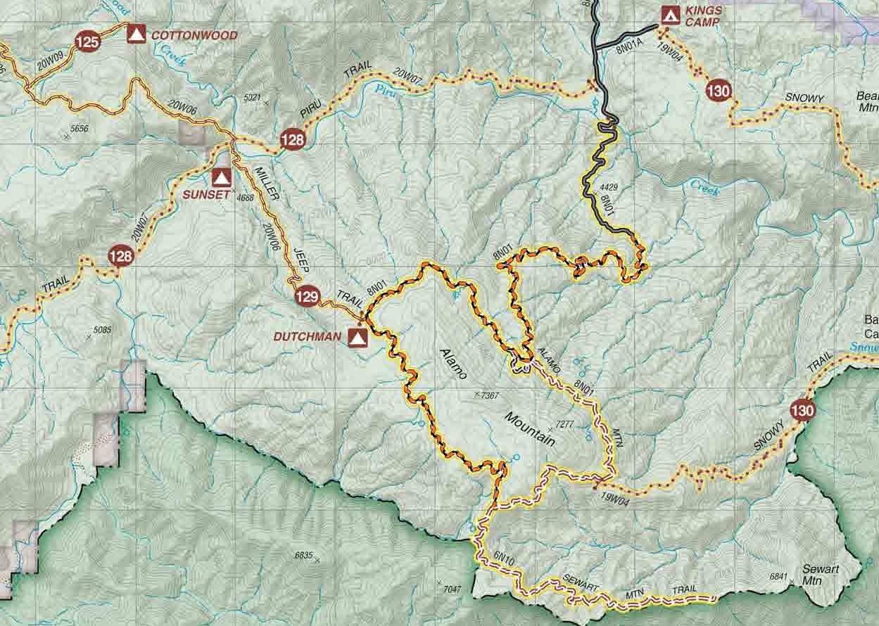
Los Padres National Forest Mt Pinos District Motor Vehicle Opportunities East Map
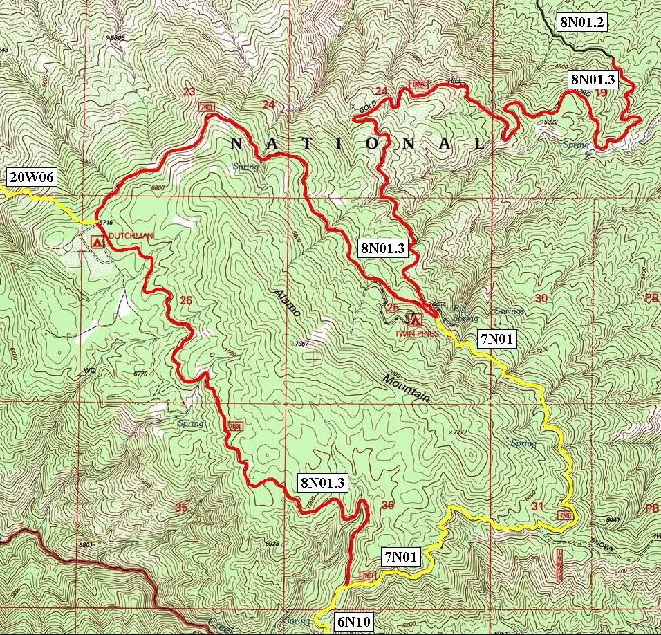
8N01.3 Gold Hill Road
Length: 10 miles
Elevation 3775' to 6800'
8N01.3 Gold Hill Road is rated green circle easiest and is open to street legal vehicles and green sticker vehicles.
Entrance at pavement ends at 8N01.2 at N34� 41.272 W118� 56.017
Exit to 7N01 at N34� 40.179 W118� 56.925
Exit to 8N01B Twin Pines at N34� 40.340 W118� 57.253
Entrance on 20W06 (129) Miller Jeep Trail at N34� 40.583 W118� 58.668
Dutchman Campground is at N34� 40.496 W118� 58.664
Exit to 6N10 at N34� 39.036 W118� 57.393
Lat/Lon format is hddd� mm.mmm WGS84 datum
It is always a good idea to call the ranger station before heading in to the forest and get a current conditions report. Los Padres National Forest Mt Pinos District Ranger Station (661) 245-3731
Los Padres National Forest Mt Pinos District Off Highway Vehicle Information
Los Padres National Forest Mt Pinos District Motor Vehicle Opportunities East Map
Length: 23 miles
Elevation: 3775' to 6800'
Los Padres National Forest Los Pinos District MVUM
Hungry Valley State Vehicular Recreation Area Map
8N01.1 Gold Hill Road
Length 6.5 miles
Elevation 3775' to 4000'
8N01.1 Gold Hill Road is open to street legal vehicles only. 8N01.1 Gold Hill Road is paved.
North Entrance on Peace Valley Road at N34� 47.760 W118� 52.133
Stipa Trail Exit at N34� 47.538 W118� 52.311
Road Runner Trail Exit at N34� 47.496 W118� 52.262
Brome Trail Exit at N34� 47.318 W118� 52.322
Gorman Trail Exit at N34� 47.086 W118� 52.474
Road Runner Trail Exit at N34� 46.812 W118� 52.870
Powerline Road Exit at N34� 46.733 W118� 52.876
Edison Canyon Campground is at N34� 46.331 W118� 52.742
Exit to Edison Canyon Trail at N34� 46.301 W118� 52.750
Exit to Coyote Trail at N34� 46.302 W118� 52.753
Exit to Freeman Overlook Trail at N34� 46.007 W118� 52.652
Exit to Sterling Canyon Trail at N34� 45.994 W118� 52.671
Sterling Canyon Campground is at N34� 45.936 W118� 52.691
Exit to Circle Canyon Trail at N34� 45.782 W118� 52.619
Exit to Old Cottonwood Trail at N34� 45.480 W118� 52.614
Upper Scrub Oaks Campground is at N34� 45.000 W118� 52.536
Lower Scrub Oaks Campground is at N34� 44.708 W118� 52.430
Exit to Flying W Trail at N34� 44.716 W118� 52.387
Exit to Maxey Ranch Road at N34� 44.664 W118� 52.371
Exit to Pipeline Road at N34� 44.664 W118� 52.371
Exit to Road Runner Trail at N34� 44.316 W118� 52.219
Exit to Jack Rabbit Trail at N34� 43.964 W118� 52.397
Exit to Hungry Valley Road at N34� 43.869 W118� 52.392
Exit to Cougar Trail at N34� 43.964 W118� 53.013
Exit to Schmidt Ranch Road at N34� 43.623 W118� 53.386
Los Padres National Forest Boundry at N34� 43.804 W118� 53.291
8N01.2 Gold Hill Road
Length 7 miles
Elevation 3775' to 4650'
8N01.2 Gold Hill Road is open to street legal vehicles only. 8N01.2 Gold Hill Road is paved.
Entrance at Los Padres National Forest Boundry at N34� 43.804 W118� 53.291
Exit to 8N01A Kings Camp at N34� 42.801 W118� 56.410
Gold Hill Campground on Piru Creek is at N34� 42.225 W118� 56.233
Pavement ends at 8N01.3 at N34� 41.272 W118� 56.017
Los Padres National Forest Mt Pinos District Motor Vehicle Opportunities East Map
8N01.3 Gold Hill Road
Length: 10 miles
Elevation 3775' to 6800'
8N01.3 Gold Hill Road is rated green circle easiest and is open to street legal vehicles and green sticker vehicles.
Entrance at pavement ends at 8N01.2 at N34� 41.272 W118� 56.017
Exit to 7N01 at N34� 40.179 W118� 56.925
Exit to 8N01B Twin Pines at N34� 40.340 W118� 57.253
Entrance on 20W06 (129) Miller Jeep Trail at N34� 40.583 W118� 58.668
Dutchman Campground is at N34� 40.496 W118� 58.664
Exit to 6N10 at N34� 39.036 W118� 57.393
Lat/Lon format is hddd� mm.mmm WGS84 datum
It is always a good idea to call the ranger station before heading in to the forest and get a current conditions report. Los Padres National Forest Mt Pinos District Ranger Station (661) 245-3731
Los Padres National Forest Mt Pinos District Off Highway Vehicle Information
Los Padres National Forest Mt Pinos District Motor Vehicle Opportunities East Map
Comment