 Tweet
Tweet
Looking for feedback
-
27I know how to apply magnetic declination using a map and compass62.96%17I know of magnetic declination but have never used it.18.52%5What is magnetic declination?18.52%5Over 2500 hours donated to the San Bernardino National Forest. Life member of CA4WD, CORVA & BRC. Tread Lightly Trainer. Reforestation Supervisor. CASSP -
learned how to read maps with USGS quadrangle, keep a selection of them where ever I am going. I find a GPS real nice but I pull a topo and compass when I am scratching my head as orientation and landmarks can get me out faster than anythingcensored for having an opinion -
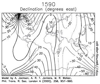
I do like this chart though
 censored for having an opinion
Comment
-
Jim,
Not to show my stupidity - the map shows how magnetic north in constantly shifting?
Some thoughts:
1. Could the mnagnetic shift affect weather patterns?
2. Does the sun's solar spot activity affect the movement of the magnetic north point?SBCO Fire Dept. CERT volunteer
MJR moderator
MJR Adopt-a-Trail Crew member
Jeep Patrol Leader
Reforestation Supervisor
Licensed Ham - n6ujm
Eagle ScoutComment
-
Roger,
Yes, the map shows how the magnetic north changes. There's iPhone apps to give you real-time magnetic declination based on where you are located.
1. I would think so, but don't know for sure.
2. In the Map & Compass class by Tracy Lenocker (OHV/AAT class) we were told that the factors influencing declination are: Location, Local magnetic anomalies, Altitude, Secular change, Diurnal change, and Solar magnetic activity.If we aren't supposed to eat animals, then why are they made out of meat?
http://jeep.matandtiff.com/
Truth is treason in the empire of lies. -Ron PaulComment
-
Question,
Doesn't an adjustable compass compensate for magmetic declination if you know how many degrees of correction you need? And would this mainly be used for finding an exact phyical location or say a geo-cache? Probably not necessary if following an actual trail.
MitchComment
-
Yes if you know how many degrees of correction you need and your compass has declination compensation you don't need to do any math for adjustment.
It is used for finding headings if you're using a map and compass for navigation.
Map to Navigation: You have a map, and you know you want to go to a certain heading, you know when you follow your compass you'll be heading the very close to the right direction.
Navigation to Map: You see two landmarks and read your compass for headings. You draw lines on your map from those two landmarks at the headings you read and you'll find your location on the map.If we aren't supposed to eat animals, then why are they made out of meat?
http://jeep.matandtiff.com/
Truth is treason in the empire of lies. -Ron PaulComment
-
Declination changes seasonally ~1 degree. I thought I needed one of the military standard Lenstatic compasses. They are really good for shooting an accurate azimuth but I think that when I am tired or distracted I could easily make an error in my declination correction and by nearly 30 degrees. Even if you have a trail to follow an inaccuracy in declination will prevent you from knowing where on the trail you are, or if you are still on the right trail. It’s not a difficult adjustment s and you can find your declination adjustment lots of places. Here for example:
http://www.ngdc.noaa.gov/geomagmodels/Declination.jspThose left standing
Will make millions
Writing books on ways
It should have been
-Incubus "Warning"Comment
-
Thanks for the info.Comment
-
[COLOR="Sienna"] I have never seen a civilian "delclination station" (for your compass).
As you know, there is the magnetic declination to go from magnetic azimuth to map azimuth... but also every compass is different and should be "decked" to see how far off your particular compass is from true magnetic north. [/COLOR]
[COLOR="Sienna"] This is known as a "resection". Don't forget that you must apply your declination (the difference between a map azimuth to a magnetic azimuth). If not, you could be off by 500m or more.Navigation to Map: You see two landmarks and read your compass for headings. You draw lines on your map from those two landmarks at the headings you read and you'll find your location on the map.
That is... unless your compass is already adjusted for declination. I tend not to do this, I always do the math, because things get bumped and I sometimes forget if I've adjusted the compass already. [/COLOR]Last edited by USMC 0369; 07-26-10, 12:38 PM.[COLOR="darkred"]"Death Smiles at Everyone... Marines Smile Back."
Adopt-a-Trail Member.[/COLOR]Comment
-
A good compass can be set once a year and kinda leave it alone, I mean as we use maps we are just getting close with a compass, I tend to use it for orientation, then landmark using the topo features, with a good compass that can get you within a degree or 2. Problem with setting it is you are always in a different location and the lines shown on that map divide by 10 (using it as an example, I know there are better charts) so you can see how fast it can change.
I know that with a good quadrangle map, I can orientate with a compass and then set myself into, say for example, the northwest corner of section 20 of the 16th township of township 2 north range 3 west, which called in could have a helicopter on me fast. It would take me a few more minutes to get it further broken down.
However, if I want exact I can use the GPS.
I kinda fought GPS till it got dirt cheap because I had learned how to read a map, I know it is a big trend to use it exclusively now but I really believe that Fishpoet is doing a great service by having these online or on the OAUSA net classes. I think everyone should know how to read a quadrangle map and have them of the area they are in if they want to be able to get a quick response. I have been told that relaying info by the township and range method gets a emergency response quicker than most anything as the guys have all been trained on it for years and use it for pinpointing where with calling in cords they are searching the map in reverse.
Kinda like saying section of section of township
of t3s x r2e a finger is on that pronto dentay where with longitude latitude they have to stretch out the map and cross reference it hoping you know those cords are correct.censored for having an opinionComment
-
fun fact...the earths magnetic pole actually flips every 300000 years on avg.Comment
-
Fun Fact 2, declination degrees printed on maps can be as old as 40 plus years. So you see they are a guideline at best.censored for having an opinionComment
-
if you get a map that's too old you may have to add 180 degrees of declination jk lolComment
-
Once upon a time, many years ago, among my responsibilities was re-certifying the compass rose at MCAS El Toro.
This is before there was GPS, and our airplanes had inertial navigation systems,and still used the magnetic compass while flying.
We re-shot the compass rose every 3 months, and usually had a few minutes of variance.
More recently, I spent some time teaching Boy Scouts how to correct for magnetic declination...
Dave_W6DPSComment
Comment