Announcement

Collapse
No announcement yet.

Can u see it?

Collapse

Forum Thread First Post

Collapse
X
 
  • Filter
  • Time
  • Show
Clear All
new posts

  • Can u see it?

    Was out on some bunny rabbit trails yesterday. Caught up with some folks from JA Bob and Bill. Swung around to to talk to Bob and talk about is new full hydro steering

    He looks up at this shear mountain wall and says hey is that a trail up thar? Yeah from our placement u could only seen a tad.

    Heres a sat image. Yeah I need to check this one out.
    Waz up thar?? Can it be wheeled? Do u see it? Stay tuned...

    97 TJ Buffed Out

    LETS ROCK!
    WEB site

  • #2
    I wouldn't pay it no nevermind, Vern.
    Old fart like you - you'll pop a gasket hiking up there.

    Comment


    • #3
      holy jeez...This should be interesting. Id guess that its not fully intact, be careful if you drive it!

      Tam
      2002 TJ on 35s a bit of lift with some stuff
      Rock-ItMan all the way around

      Comment


      • #4
        Sweeeet, but wait til those earthquakes are done shakin
        :gun:'99 TJ Sport:gun:

        Comment


        • #5
          Originally posted by robert-r View Post
          I wouldn't pay it no nevermind, Vern.
          Old fart like you - you'll pop a gasket hiking up there.
          Ya i think i can do this one B
          97 TJ Buffed Out

          LETS ROCK!
          WEB site

          Comment


          • #6
            Ridge Trail

            Here it is.
            [SIZED]http://britain.connectnet.com/Photography/MineTrail/photos/photo1.jpg[/SIZED]

            Dang First Problem....
            [SIZED]http://britain.connectnet.com/Photography/MineTrail/photos/photo2.jpg[/SIZED]

            Ok get the ole backpack out and lets go!
            The end of trail and the goods! The Mine area. This isnt listed on any maps I have...
            [SIZED]http://britain.connectnet.com/Photography/MineTrail/photos/photo11.jpg[/SIZED]

            Ok lets get the tools out and find something...
            [SIZED]http://britain.connectnet.com/Photography/MineTrail/photos/photo22.jpg[/SIZED]

            More Here

            The trail was a bit washed out no vehicle would have made it. From the road growth the trail hasnt been used for decades..it was a good day!
            97 TJ Buffed Out

            LETS ROCK!
            WEB site

            Comment


            • #7
              Wow! Great photos. The views are beautiful and the flower shots are excellent. Where is this near?

              What was up with the downed plane? Crash Landing I assume?
              [COLOR=#ff8c00]MYJEEP(crawls)ROCKS(again).com

              I have finally stopped drinking for good.
              Now I drink for evil..... :devil:
              [/COLOR]

              Comment


              • #8
                That's really cool. I love being able to find sat images and go explore them. I think I do that everytime I go to Calico.

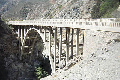
                I've been looking at an image of an old concrete bridge nearby. This thing is HUGE!!! It's one hell of a hike to get to it though. Apparently it was constructed and the entire project was scrapped. In front of it is dirt road and behind it is a cliff face.

                http://www.google.com/maps?f=q&hl=en...06496&t=h&om=1

                "The problem with socialism is that eventually you run out of other people's money."
                -Margaret Thatcher

                Comment


                • #9
                  Originally posted by Shadly1 View Post
                  That's really cool. I love being able to find sat images and go explore them. I think I do that everytime I go to Calico.

                  I've been looking at an image of an old concrete bridge nearby. This thing is HUGE!!! It's one hell of a hike to get to it though. Apparently it was constructed and the entire project was scrapped. In front of it is dirt road and behind it is a cliff face.

                  http://www.google.com/maps?f=q&hl=en...06496&t=h&om=1

                  that is called "the bridge to nowhere" in azusa canyon.
                  i have been there many times.
                  http://www.2020hindsight.org/2001/07/27.html

                  it is a nice hike, but dont leave anything in your car when you go
                  >>>>>>>>>>>>>>>>>>>>>>>>>>
                  ERIK


                  95 yj, locked lifted, and ready to rock!

                  Comment


                  • #10
                    Originally posted by NAILER341 View Post
                    that is called "the bridge to nowhere" in azusa canyon.
                    i have been there many times.
                    http://www.2020hindsight.org/2001/07/27.html

                    it is a nice hike, but dont leave anything in your car when you go
                    That's great! I'm sorry the bridge claimed your sole. I'd love to find old relics like that I can drive to. I know that's not one of them.

                    Edit: I guess it didn't claim your sole. I thought that was your blog. Oops
                    Last edited by Shadly1; 03-08-08, 11:28 PM.
                    "The problem with socialism is that eventually you run out of other people's money."
                    -Margaret Thatcher

                    Comment


                    • #11
                      no.. not my blog
                      it is worth the hike to see it.
                      you might cross a bear, or even a couple of mountain sheep.
                      in my many times out there in the past i have seen both.
                      for being in the angeles crest area, there is actually still some wildlife out there.
                      >>>>>>>>>>>>>>>>>>>>>>>>>>
                      ERIK


                      95 yj, locked lifted, and ready to rock!

                      Comment


                      • #12
                        Originally posted by Malachi View Post
                        Wow! Great photos. The views are beautiful and the flower shots are excellent. Where is this near?

                        What was up with the downed plane? Crash Landing I assume?
                        Western side of Borrego, Rodriguez Canyon. Theres a loop which will swing on around and down Oriflamme creek.

                        Plane..I scanned the runway didnt see any skids but didnt look very hard. Its a shame was a very nice low wing plane. Sure beats flying a Cessna...There also a V tail Bonanza parked on same strip.

                        Oh hiked to that bridge in early 70's same saying dont leave nothing valuable in your car..somethings never change...
                        97 TJ Buffed Out

                        LETS ROCK!
                        WEB site

                        Comment


                        • #13
                          I just couldnt figure out why someone would put out the expence to put that trail road in. Its cut through some tough stuff. Those quartz vain mines just didnt figure. Thats lots of road for those little mines...untill I reviewed all of the pictures in detail..and this came out, Those are the real mines!

                          Gonna have to go back in ....

                          [SIZED]http://britain.connectnet.com/Photography/Other-mines.jpg[/SIZED]
                          97 TJ Buffed Out

                          LETS ROCK!
                          WEB site

                          Comment


                          • #14
                            Originally posted by Britain View Post
                            Here it is.
                            [SIZED]http://britain.connectnet.com/Photography/MineTrail/photos/photo1.jpg[/SIZED]

                            Dang First Problem....
                            [SIZED]http://britain.connectnet.com/Photography/MineTrail/photos/photo2.jpg[/SIZED]

                            Ok get the ole backpack out and lets go!
                            The end of trail and the goods! The Mine area. This isnt listed on any maps I have...
                            [SIZED]http://britain.connectnet.com/Photography/MineTrail/photos/photo11.jpg[/SIZED]

                            Ok lets get the tools out and find something...
                            [SIZED]http://britain.connectnet.com/Photography/MineTrail/photos/photo22.jpg[/SIZED]

                            More Here

                            The trail was a bit washed out no vehicle would have made it. From the road growth the trail hasnt been used for decades..it was a good day!
                            I'm glad you checked that out Vern!
                            Was curious as to what was up there.
                            Funny.... 3 weeks ago... snow there... now it's bloomin' spring.
                            What do you think they were mining?

                            Comment


                            • #15
                              Hey B,
                              Quest for the lost arc? These are not on any map that I have. Wonder how someone desides to dig for something.....Got a Volcano to check out next week, some rumbling been going on under it.....
                              97 TJ Buffed Out

                              LETS ROCK!
                              WEB site

                              Comment

                              Working...
                              X