 Tweet
Tweet
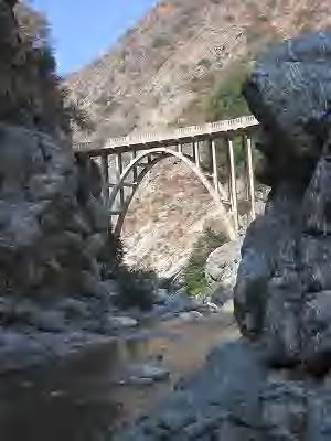
HAS ANYONE EVER TRIED TO GET TO OR HAVE ANY INFO ON THE BRIDGE TO NOWHERE IN THE AZUSA CANYON? GPS COORDS ARE lat=34.2828385531, lon=-117.747219505 . IS IT POSSIBLE TO GET TO IN A JEEP?
-
-
From what Ive heard and read, this is a hiking trail only. But it does sound real coolOriginally posted by ECHO View Post
Tam2002 TJ on 35s a bit of lift with some stuff
Rock-ItMan all the way around -
it is indeed a hiking only trail. it is worth the walk though. i have been there many many times. there are a few really cool mines on the way there, if you know where to look. there are also some rams out ther. i think you have to be lucky to see them, but you just might.
ihave seen them a few times while hiking in that area.
sometimes, you'll even see some bungee jumpers illegally throwing themselves off of the bridge. interesting to watch. considering the water is about one foot deep under there... not the brightest idea
in order to hike to the "bridge to nowhere" you have to cross the river 3 times. it is generally not an issue, but after a rain, or thaw it can be rough.
when you get to the end of the road in azusa, you'll see quite a lot of grafiti, and other unsightly b.s.
that will all disappear after the first river crossing.
it seems the scum dontlike to get their feet wet. >>>>>>>>>>>>>>>>>>>>>>>>>>
ERIK
95 yj, locked lifted, and ready to rock!Comment
-
I have also hiked to the bridge a few times- great hike, about 10 miles rt as I recall. Do it in the late spring or fall though.Comment
-
I have been up there a couple of times. Beware of poison oak, especially at this time of year as it has no leaves but the branches will still spread the oil.
This is the write up off geocaching.com
Around 9 miles round trip. Great fun. Plan to get a little wet.
Directions to Trailhead: Off the 210 FWY in Azusa, take the Azusa Ave offramp and head North, towards the mountains. Continue North for about 2 miles until you come to the last intersection before entering Azusa Canyon, this will be Sierra Madre Ave.. On the left will be a Stop N Go convenience store where you can purchase an Angeles Forest Adventure Pass which is required to park at the trailhead. Adventure Passes can also be purchased at the ranger station about a mile further up Azusa Ave but it doesn't open until 9AM. Continue up Azusa Canyon for about 8 miles, past the two reservoirs, until you come to the intersection of the East Fork Road. Turn right on the bridge over the Off Highway Vehicle (OHV) area and continue on for about 5 miles. The road ends in the Coyote Flats parking lot, which has bathroom facilities. The trail starts just beyond a large yellow gate.
There are quite a few river crossings along the first part of the trail so be prepared to get a little wet. The best time to do this hike is late spring, early summer. Too early in the Spring, the river can be running too strong for a safe crossing, especially the first couple of crossings. Be sure to bring plenty of water (at least 3 bottles) unless you have a portable water filter. Even though there is plenty of water in the river and it looks clean, it is not advisable to drink it.
The trail itself follows the remnants of a roadway that the Army Corps of Engineers was attempting to build in the 1930's as an alternative route to the high desert than Angeles Crest Highway. However in the Spring of 1938 a massive rainstorm (more than 12" in less than 24 hours) hit the San Gabriel Mountains and the resulting flood wiped out nearly all the road work. It has been estimated that nearly a hundred feet of water was flowing thru the gorge spanned by the bridge and it was only the height of the bridge span (150') that saved it. It can get Hot but when you get to the final destination don't hesitate do take a dip in the river and have a nice lunch. If you're lucky you might see a group of bungee jumpers in the area. Look out for rattle snakes!Over 2500 hours donated to the San Bernardino National Forest. Life member of CA4WD, CORVA & BRC. Tread Lightly Trainer. Reforestation Supervisor. CASSPComment
-
sorry to be slightly off topic here, but how does the illegal bungee jump work? What is the bungee attached to that allows for the controlled disconnect after the jump?Comment
-
I Just Found A Lot Of Info Online About The Bridge With Some Nice Pics. Has There Ever Been An Mjr Hike?Comment
-
i am not a bungee jumper, nor do i know about the process of jumping, or rreleasing yourself after a jump.Originally posted by grub View Post
i do know, having spoken with the jumpers i saw at the time, that they were not permitted to jump as the proper permits were not filed.
it looked like they had nice equipment, but it all looks the same to me
>>>>>>>>>>>>>>>>>>>>>>>>>>
ERIK
95 yj, locked lifted, and ready to rock!Comment
-
According To Some Of The Info I Found, A Company Called Bungee America Inc. Claims To Own Part Of This Area And Has Posted Signs Stating It Is Private Property. The Company Takes Organized Groups In On Saturdays And They Jump From The Bridge.Comment
-
maybe they found a way around the permitsOriginally posted by ECHO View Post
it has been a long time since i have been back there. at that time, they were jumping for kicks, not money
>>>>>>>>>>>>>>>>>>>>>>>>>>
ERIK
95 yj, locked lifted, and ready to rock!Comment
-
I was there 2 years ago and I do not remember any no trespassing signs. I believe that all the land around the bridge is National Forest. Maybe the bungee jumpers have a license to use the bridge.Originally posted by ECHO View PostOver 2500 hours donated to the San Bernardino National Forest. Life member of CA4WD, CORVA & BRC. Tread Lightly Trainer. Reforestation Supervisor. CASSPComment
-
The Page I Got The Info From Is Dated Sep Of 2003. Its Possible The Sign Has Been Removed. It Was Supposedly Located Between The 4 1/4 Mile Marker And The Bridge. The Pics That Were Posted Showed The Sign Had Quite A Few Bullet Holes In It. Anyone Planning On Going Up There Anytime Soon?Comment
-
I FAILED TO ACKNOWLEDGE THIS COMMENT EARLIER....I HATE SCUMOriginally posted by NAILER341 View PostComment
-
Interesting...I'd like to go up there and see that one day...
http://en.wikipedia.org/wiki/Bridge_...riel_Mountains)
 -Bob
-Bob
'98 Black TJ [COLOR=Blue]Sport[/COLOR] 4.0L/Auto Trans
My rig : http://i9.photobucket.com/albums/a95...n/DSC06310.jpg
Comment
-
I Would Like To Check It Out Before It Gets Too Cold. There Is Supposed To Be Some Great Trout Fishing Around The Bridge Too If Anyone Likes Doing That.Comment
Comment