 Tweet
Tweet
San Juan Public Lands Map
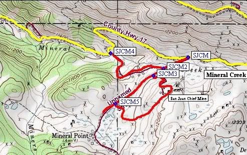
San Juan Chief Mine
Length: 2 miles
Elevation: 11,400' to 11,850'
Trail rating: Blue Square More Difficult - Street legal vehicles and unlicensed off-highway vehicles allowed.
Special Note Operators of unlicensed vehicles must have a valid drivers license and carry proof of liability insurance.
East Entrance on Mineral Creek at N37� 57.699 W107� 35.141
West Entrance on Mineral Creek at N37� 57.724 W107� 35.719
Lat/Lon format is hddd� mm.mmm WGS84 datum
It is always a good idea to call ahead and get a current conditions report. San Juan Public Lands Office (970) 247-4874.